The heat returns to Central Florida this weekend. Get the details on how hot it will be and how long the dry weather will last.
Weather Forecast Discussion

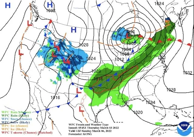
High pressure will continue to control the weather in Central Florida as the weekend begins. This large Bermuda high will continue to force storms to track towards the Great Lakes region. This will allow much of the U.S. to see above normal temperatures this weekend.
The expected surface map for Saturday at 8:00AM is below, and you can see a storm system heading though the Great Lakes. A frontal boundary will slowly make its way through the Southeast U.S. Any shower activity from that front will likely hold off until late Monday or Tuesday in the Orlando area. I’ll post a quick update Monday on Twitter (see below) with any changes to Monday’s forecast.

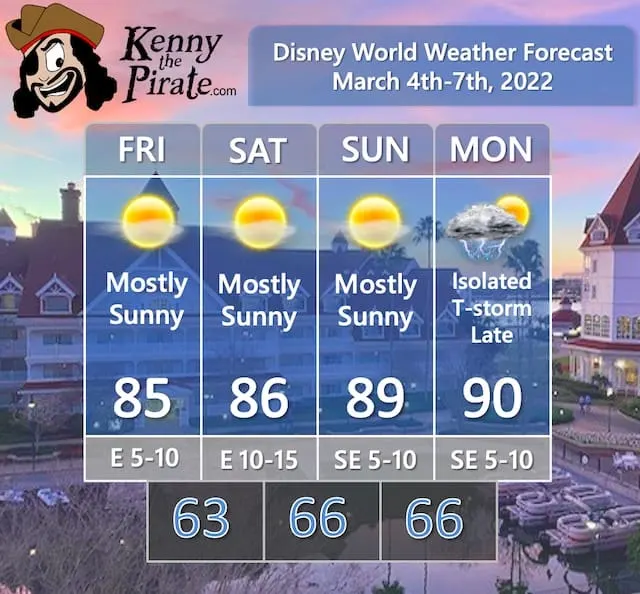
Ahead of that front, temperatures will really warm up, with highs approaching 90 by Monday in Orlando. Stay cool if you are headed to the theme parks!
Official KtP Weather Forecast

Severe Weather Chances For Florida
No severe weather is expected with dry weather forecast through most of this weekend. While any thunderstorm can produce gusty winds, frequent lightning, and heavy downpours, the isolated thunderstorms that would develop Monday are expected to remain below severe criteria.
In addition, any shower/thunderstorm activity for the middle of next week (more on that below) should not be severe.
Flight Impacts

I added this category recently to point out any large-scale impacts on flights getting to and from Orlando. The struggles and impacts on the airline industry in the wake of the pandemic that led to flight cancellations have been well-documented. I’m focusing on the weather impacts.
We’ll start off this forecast period with minor flight delays possible in California on Friday. That threat will shift to the Rocky Mountains on Saturday. As the storm system moves towards the Great Lakes, delays are possible on Sunday and Monday in the Ohio Valley and Southeast U.S. due to thunderstorms.
A Look Ahead

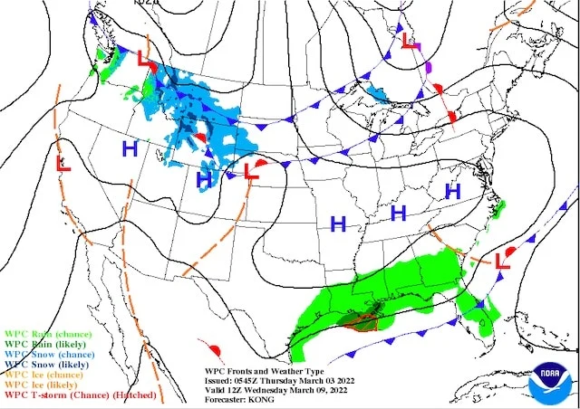
An early look at next week shows a frontal boundary stalling across Florida for Tuesday and Wednesday. This looks to bring just isolated shower activity as noted on the Tuesday surface map below.
One other note, some computer model guidance has an area of low pressure developing along that stalled front and bringing rain to the area towards the end of next week. Lots of time to watch that potential system and see if anything comes to fruition.

Are you headed to Disney World this week? Will the hot weather force you to adjust your plans? Let us know in the comments below or on Facebook!
Discover more from KennythePirate.com
Subscribe to get the latest posts sent to your email.


What do you think?